Fuel Along Intercoastal

Master Drago

Cadet
Joined
Nov 8, 2008
Messages
8
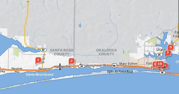
We're planning a trip to the Florida panhandle this Summer and expect to burn a few tanks of fuel (~100 gallons). I did some Google searches and came up empty when trying to find fuel (gasoline) in the area near Navarre Beach Florida. We'll be cruising between Pensacola and Destin mostly. Can anyone help with places to get fuel near Navarre Beach - where we'll be renting a house with a slip?

Thanks,
Kenneth Drake
 

smclear

Chief Petty Officer
Joined
Jul 14, 2008
Messages
626
Re: Fuel Along Intercoastal

I'm sure a lot of local folks will chime in with suggestions but have you considered purchasing a cruising guide. These are often filled with that type of info and a whole lot more.
 

Master Drago

Cadet
Joined
Nov 8, 2008
Messages
8
Re: Fuel Along Intercoastal

Thanks for that suggestion. I had not thought of a cruising guide! I just ordered Cruising Guide to the Northern Gulf Coast: Florida, Alabama, Mississippi, Louisiana (Paperback) by Claiborne S. Young, even though it is slightly dated (2004).
 

jeffnick

Senior Chief Petty Officer
Joined
May 24, 2004
Messages
695
Re: Fuel Along Intercoastal

You might try looking on Active Captain
http://www.activecaptain.com/OTW.php
AC-Marina.jpg
 

rsimmons42

Petty Officer 2nd Class
Joined
Aug 25, 2008
Messages
194
Re: Fuel Along Intercoastal

just inside the Destin Pass there is about 5 places to get fuel. As soon as you come in the pass, turn to the right before the bridge you will see plenty of spots. If they are full go under the bride and the first dock on the right has fuel as well.
 

bowman316

Lieutenant Commander
Joined
Oct 21, 2008
Messages
1,822
Re: Fuel Along Intercoastal

yea, active captain is great, just look at the map and plan your route, and it will tell you where all of the marinas are, and what they have there.

Anchoarages too.
 
Joined
Mar 25, 2009
Messages
10
Re: Fuel Along Intercoastal

One thing pretty cool that's coming is the ability to show all of the ActiveCaptain markers over NOAA charts. You can also tell it to "only show marinas with fuel". The picture below is a screen shot of the area you're interested in with NOAA Charts selected. Red markers are marinas, green ones are anchorages. There are also blue markers showing bridges, inlets, boat ramps, and a ton of other stuff. This version is from the X Preview which is a preview for the full application coming out in April. It's completely free.

attachment.php
 

Attachments

  • XPreview2.gif
    XPreview2.gif
    55.8 KB · Views: 0

Edko

Petty Officer 1st Class
Joined
Aug 4, 2008
Messages
247
Re: Fuel Along Intercoastal

It's completely free.

Which makes you a pretty decent human being in my book.

That looks great with the charts.
 

Master Drago

Cadet
Joined
Nov 8, 2008
Messages
8
Re: Fuel Along Intercoastal

Thanks all of you folks. I had never heard of this application before. It will be a great help. I just began boating last year in February.

Kenneth Drake
 
Joined
Mar 25, 2009
Messages
10
Re: Fuel Along Intercoastal

Which makes you a pretty decent human being in my book.
Actually, my real intent is to give me the data that I really want when I go cruising!

I figure that if I'm satisfying my own needs, others will find use in it too.
 
Top