arks
Lieutenant Commander
- Joined
- Nov 7, 2002
- Messages
- 1,967
Re: Upper Chesapeake Raftup! -- July 18 --
#1- Hey, if it's not YOUR wedding then you can bag it, and....
#2- beg or borrow a boat if you have to!
Hope you can figure a way to attend.
Anyway, I promised more info so here it is.
For all you techno-geeks, the coordinates for Sand Island are as follows:
LA 39 degrees 29.7 minutes N
LO 76 degrees 05.5 minutes W
The most likely raftup spot will be between the marked Havre de Grace channel and the island, near the southeastern end. The final position won't be confirmed until we see how the wind/weather conditions are that morning.
That particular position should be OK not only for rafting/swimming, but for fishing too.
If anyone wants to waterski, that spot is at the edge of a large area we used to ski regularly with our 23 footer. There's even 2 bouyed slalom courses close by if you're into that.
NOTE: for those who've never boated the area, be aware of shallow water. Please buy AND USE a chart. A sounder is a wise investment, too. Most of the bottom is mud or sand but a grounding is never good.
The closest public launch ramp is Havre de Grace City Yacht Basin at Tydings Park. More info here: http://www.havredegracemd.com/departments_city_yacht.php
Other ramps in the area:
Havre de Grace-Tidewater Marina, Jean Roberts Park
Charlestown- Public ramp across from Wellwood Restaurant
Elk Neck State Park- Rogues Harbor (Elk River 2 miles N of Turkey Point)
Town of Northeast- Anchor Marina, Bay Boat Works
For this event I'll monitor VHF channel 09. Hail "Winter Dream" when approaching so we know you intend to join us. If 09 is active we may need to switch channels to converse, but the initial contact should be on 09.
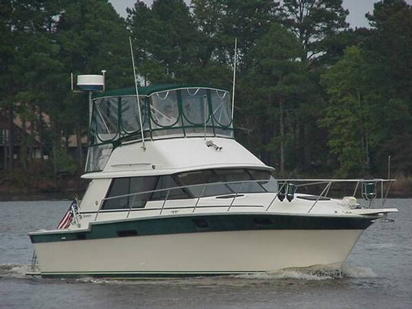
Here's a pic of my Silverton so you know what to look for. Her name is on the stern.
Hope to see everyone who's responded so far- AND MORE!!
#1- Hey, if it's not YOUR wedding then you can bag it, and....
#2- beg or borrow a boat if you have to!
Hope you can figure a way to attend.
Anyway, I promised more info so here it is.
For all you techno-geeks, the coordinates for Sand Island are as follows:
LA 39 degrees 29.7 minutes N
LO 76 degrees 05.5 minutes W
The most likely raftup spot will be between the marked Havre de Grace channel and the island, near the southeastern end. The final position won't be confirmed until we see how the wind/weather conditions are that morning.
That particular position should be OK not only for rafting/swimming, but for fishing too.
If anyone wants to waterski, that spot is at the edge of a large area we used to ski regularly with our 23 footer. There's even 2 bouyed slalom courses close by if you're into that.
NOTE: for those who've never boated the area, be aware of shallow water. Please buy AND USE a chart. A sounder is a wise investment, too. Most of the bottom is mud or sand but a grounding is never good.
The closest public launch ramp is Havre de Grace City Yacht Basin at Tydings Park. More info here: http://www.havredegracemd.com/departments_city_yacht.php
Other ramps in the area:
Havre de Grace-Tidewater Marina, Jean Roberts Park
Charlestown- Public ramp across from Wellwood Restaurant
Elk Neck State Park- Rogues Harbor (Elk River 2 miles N of Turkey Point)
Town of Northeast- Anchor Marina, Bay Boat Works
For this event I'll monitor VHF channel 09. Hail "Winter Dream" when approaching so we know you intend to join us. If 09 is active we may need to switch channels to converse, but the initial contact should be on 09.
Here's a pic of my Silverton so you know what to look for. Her name is on the stern.
Hope to see everyone who's responded so far- AND MORE!!