four winns 214
Senior Chief Petty Officer
- Joined
- Oct 25, 2008
- Messages
- 769
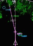
I fly big airplanes for a living. This morning I flew from Europe to the the U.S. All along the coast of Canada are a series of fixes that are used as "Coast-in" points for airplanes crossing the North Atlantic. They're also used as "Coast-out" fixes for airplanes heading the opposite direction. The fixes all have five-letter names and are located approximately 120 miles off shore. Many have nonsensical names like ALTOD or KETLA, but some are given names that reflect the map makers' interests. This morning my route took me over one named for a type of boat, DORYY, which is just south of CUDDY. DORYY has a double "Y" because the fixes must have five letters so an extra "y" was added.
The picture shows my cockpit moving map display showing the two fixes. They're about 160 miles northeast of Goose Bay, Labrador, Canada, represented by the blue circle labeled CYYR. The green areas are the Canadian coast line as depicted by the Enhanced Ground Prox system. I know there are more than a few pilots on iBoats and thought they might find this of interest.
The picture shows my cockpit moving map display showing the two fixes. They're about 160 miles northeast of Goose Bay, Labrador, Canada, represented by the blue circle labeled CYYR. The green areas are the Canadian coast line as depicted by the Enhanced Ground Prox system. I know there are more than a few pilots on iBoats and thought they might find this of interest.